


z le lac des escarcets 08-06-21

cb8310
User
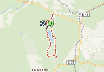

Length
5.7 km

Max alt
114 m

Uphill gradient
49 m
Km-Effort
6.4 km

Min alt
71 m

Downhill gradient
48 m
Boucle
Yes
Creation date :
2021-06-08 09:07:46.744
Updated on :
2021-06-09 06:17:34.171
1h53
Difficulty : Easy

FREE GPS app for hiking
 SityTrail
IGN / Geographical institutes
SityTrail Plus
The world is yours!
About
Trail Walking of 5.7 km to be discovered at Provence-Alpes-Côte d'Azur, Var, Le Cannet-des-Maures. This trail is proposed by cb8310.
Description
rando sans difficultés sur un parcours très ombragé mais par une piste à partir de la route complètement détériorée
Photos


Positioning
Country:
France
Region :
Provence-Alpes-Côte d'Azur
Department/Province :
Var
Municipality :
Le Cannet-des-Maures
Location:
Unknown
Start:(Dec)
Start:(UTM)
289934 ; 4802636 (32T) N.
Comments